| I’m lucky enough to live near
the Lower Wisconsin River – 93 miles of primitive,
undammed river. It is shallow and full of sandbars
that are open to the public. Some have enough vegetation
to be true islands. Jim Michalak designed Polepunt
for exactly this kind of water, and Wojtek Baginski
built the prototype for the eerily-similar Wistula
River in Poland. HERE
is a link to Wojtek’s adventures.
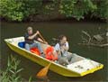
We made a family event of taking an afternoon to
paddle seven of those miles. My parents rented a Grumman
aluminum canoe from one of the outfitters in Sauk
City, and were kind enough to pay the $5 to have the
Polepunt shuttled back as well. We were very fortunate
to have several days of 75 degrees F and moderate
humidity. Normally southern Wisconsin is far more
tropical in July.
 (click images for larger views)
It pays to call around about the cost of having them
shuttle your boat, as prices vary wildly. Another
place wanted $20, but for $5 there is no point at
all in doing your own shuttle or poling upstream.
Here’s the upstream view from the launching
point.

Note that I’m actually in the picture. As an
avid (more like rabid) photographer, my dad took many
of the photos in this article. Here’s the downstream
view.

Not far past that highway bridge is the only sort-of
scary obstacle. There is an abandoned rail bridge
that offers safe passage to canoes only to the far
right. There are whirlpools elsewhere that can capsize
canoes and hold swimmers under for a long time. Here
is a photo from downstream, since upstream we were
busy making a fast paddle to the right to get in the
right place.

With the drought conditions, the dam at Prairie du
Sac was letting rather little water through. So the
current was slow and the whirlpool didn’t look
all that scary. I would still have stayed away in
a tippy canoe, but I bet the punt could have bulldozed
right over it with a few powerful strokes. It is right
there in the photo, under the trussed section. It
just doesn’t look like much.
Shortly after the rail bridge we were rewarded with
a view of a blue heron.

Here are the grandparents paddling.

…and here they are aground. Most of this river
is ankle deep, so you get used to this. Or you learn
to tell the difference between riffles over a bar
and wind ripples. It is not easy when the current
is light like this.

But this is an interesting point of comparison between
the punt and the canoe. The punt floats in less water
than a canoe, and sometimes we could drift over bars
that would ground the canoe. But the canoe is a lot
faster at getting to the right part of the river to
miss a bar. Basically, the grandparents could paddle
slow and easy and had no trouble keeping up even with
arthritic joints. We had to paddle pretty hard a few
times, and use the pole once when we were upstream
from a bar I was pretty sure would ground us hard.
But the payoff is in stability. You get to stand
up to survey the river ahead, and it is no big deal
if both kids rush to one side for a better view of
something.
Here’s a taste of the scenery on the upper
stretch, just around the bend from the rail bridge.

Not far into the trip, the kids discovered the joys
of a very stable boat. Rhea liked dragging her feet
in the water, and Thalia attempted to assist the boat’s
propulsion by splashing her feet.


Thalia found another way to amuse herself when the
splashing got too annoying to adults trying to talk.

A bit before halfway down we saw our first trace
of motor traffic.

Halfway down is the boat landing at the Mazomanie
Oak Barrens on County Highway Y. Mazomanie, my home
town, is not directly on the river, and a bit further
downstream, past our take-out.

And just downstream of the landing is some impressive
turbulence. It almost looks like a wing dam, but I
don’t think they have any on this river. I didn’t
get close enough to determine what caused it either.

The Wisconsin DNR makes it legal to camp on the sandbars.
They don’t even charge a fee! But you have to
pack out everything you bring in, and the fine is
very steep if they catch you with any kind of glass
container.

You can see how massive some of the bars become.
Of course even more of them are just under or at the
surface. The big islands are best for “nature
breaks”, but come prepared and be watchful for
poison ivy. There’s plenty. Also be aware that
some of the islands are privately owned and posted.
Stay off of these.

Remember that stability I was talking about? Just
try either of these tricks in a canoe. Here’s
mom surveying the situation and Rhea dozing on the
foredeck.

Speaking of redheads dozing on the foredeck, you
had better believe we had lots of sunscreen on for
this experience. But strangely, we encountered almost
no bugs, and thus no need for chemical repellants.
Maybe the drought has been hard on the mosquitoes.
(I’m really trying hard to feel bad about that.)
There was one notable bug, though. This little fellow
waited patiently on the foredeck while I changed memory
cards in the camera.

Just around the bend after the Mazo landing, Ferry
Bluff comes into view. As one might guess, this was
once the site of a ferry. Probably because this tall
chunk of rock is easily visible from several miles
up or downstream. Good advertising, I guess.

After this point the river starts getting more scenic.
In this stretch, turtle-sighting became the kids’
favored pastime. Mine too, truth be told. To get close
enough for a good photo you need to paddle silently,
turning the blade sideways in the water for the recovery
stroke, and never lifting it to make a splash.

By the way, the deep side of the river is probably
the one where the bank is actively eroding.


Remember that airboat at the mazo landing? Here it
is parked on a bar while its owner suns himself.

This, by the way, is the best way to encounter an
airboat. They are quite noisy even at a distance.
But I guess nobody would debate their facility in
skipping over sandbars at great speed.
At the foot of Ferry Bluff is Honey Creek. The take-out
is a short distance up this creek. It is navigable,
but only just. You have to stay right around the first
bar, then cut radically left to stay in the deep channel.
By “deep” I mean maybe three feet, and
by “channel” I mean maybe 4 feet wide.
And of course this will probably be different after
the next big rainstorm. (This trip was July 1, 2007)
The majority give up and wade.

We saw hardly another soul until the take-out. But
once there, fellow paddlers and outfitter staff alike
commented on the punt, and all were quite impressed
that it would be poled upstream with little more effort
than paddling. In particular, an eastern European
gentleman was asking for all the details on the boat.
Fool that I am, I didn’t even think to mention
that the prototype was built in Poland! My excuse
is tired children. (Sorry Wojtek!)
The outfitter arrived right on time with a blue schoolbus
and large canoe trailer. They were going to send a
van with roof rack for the punt, but the van got stuck
waiting for one of their clients at the Arena landing
downstream. The ingenious proprietor devised a solution.


I didn’t have to lift a thing. You better believe
that’s a bargain for $5! Kudos to the outfitter.

I have the feeling that this tiny adventure is just
dipping our toes into what this boat can do. Time
will tell, and rest assured that you’ll read
all about it.
Rob Rohde-Szudy
Madison, Wisconsin, USA
robrohdeszudy@yahoo.com

Click
Here for Other Articles by Rob Rohde-Szudy
|


 Stainless Screws