Part One - Part Two - Part Three
 |
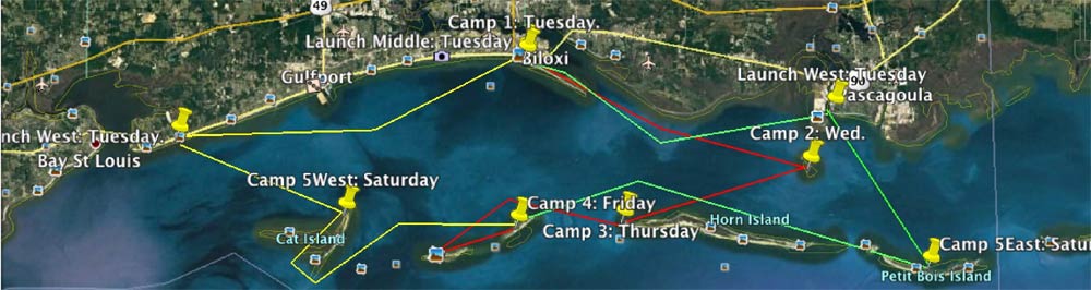
For those unfamiliar with the event, there are several events around the country embracing small boat coastal cruising and boating. The Texas 200, Florida 120, OBX 130, Everglades Challenge to name a few, and now, the relatively new, Mississippi 110. The "Mississippi 110" is a mix of offshore sailing, island hopping and coastal cruising. The Mississippi Barrier islands are 10-12 miles offshore & south of the mainland. The event has now completed its second year in existence. This event is really little more than a group of like minded sailors/boaters who want to share anchorages while sailing in the same waters. There are no rules or requirements and even the planned anchorages are, and have, changed each year due to the real-time weather that presents itself during the event. There is no "one" launch or recovery location. No checkpoints or registration requirements, no list of gear or inspections of gear or boats. I guess you can tell this is NOT an organized event. It is "an opportunity" to sail in company or at least anchor in company if you can keep up with when and where everyone will be. It is incumbent upon each Captain to assess the trip and his/her capabilities as though he were all alone when deciding to put the boat in the water. Because each of the 2016 Captains sailed different routes, launched at different ramps and sailed for more or less days, the experiences varied widely so there is no one story that would cover all the participants. Below is some of the story from my perspective about his year's "Mississippi 110" but first a little info about the outing.
2016 MS110 Participants:
- Pat Johnson - 18ft "Half Fast Cruiser" self built power boat
- Murray White - 12ft O'Day Widgeon
- Harry Garcia - 26ft Macgregor
- Steve Spanogle - 19ft O'Day Mariner
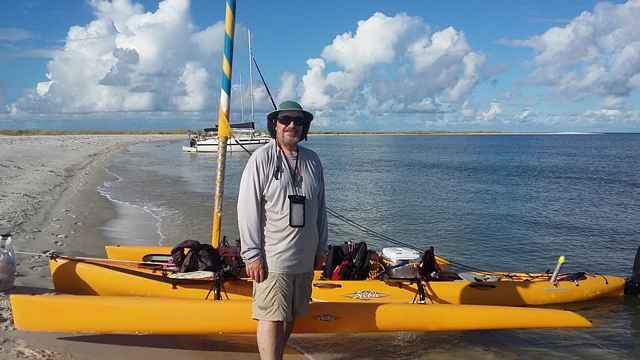
- Duff Bassett - Hobie Tandem Island trimaran
- Robert Hardin - 15ft Potter
- Travis & Kathy Rayner - 26ft Macgregor
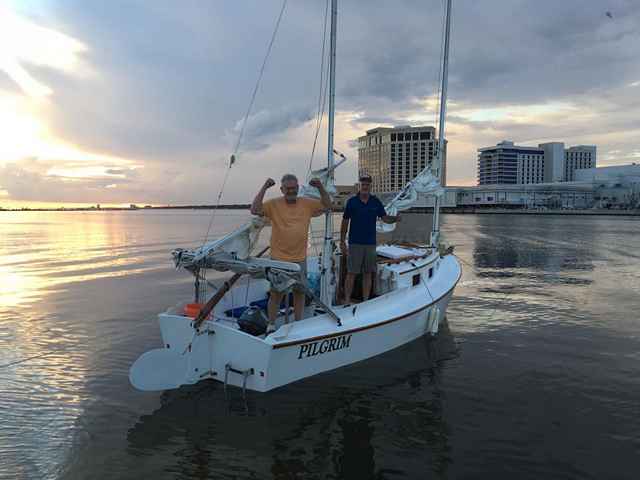
- Travis & John Votaw - 22ft "Pilgrim" Cat Ketch
Helpful links for preparing to participate:
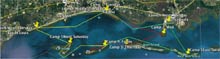
- Pat's Small Boat Map - Map Link
- Duckworks Magazine article about the trip I made in 2012 to the Barrier Islands - Article Link
- Duckworks article about the 2015 MS110 - Article Link
- Barrier Island Guide - Guide Link
- Mississippi 110 Facebook Page (this is where all the pictures are) - Facebook Page Link
More info about the MS110:
- Many of us used a Smartphone APP called "Life360" that allowed us to see where the folks (who used the APP) were at any given time. It also allowed us to send group messages telling folks where we planned to go if there were a change or if we were bailing out;
- We had Cell Phone coverage (At least from AT&T) from all the islands and during the entire trip. Data was a little slow from some of the islands but calls were no problem;
- Although most/all of us had GPS devices (mostly smart phone stuff) we rarely needed or used them because we could see where we were headed or at least had a visual reference like the tall casinos the entire time. There are few hazards once you leave the shoreline of the mainland until you reach the islands and the water is clear enough to see the shallow waters before actually entering them;
- While I am sure that there are sailors out there who could sail these waters in virtually any boat, I would remind folks that this is, at least in part, open water sailing and its several hundred miles to the next land/continent (South America) south of the area we refer to as the Mississippi Barrier Islands. When you are between the islands the conditions are "open water" ones with no more protection than what you bring with you. If something happens between the islands you could very well find yourself "Between the Devil & the Deep Blue Sea". I think small boaters should assess their boat & capabilities with a realistic eye and have a plan-B if they choose to participate;
- Although the forecasts will generally reflect 10-15mph winds and 1ft seas the conditions are likely more enhanced in the Mississippi Sound due to a long east or west fetch and relatively shallow waters. The wave frequency is likely to be every 2-3 seconds. The seas are often confused due to the southeastern (generally for the time of year) swells from the Gulf of Mexico interacting with the direction of the wind-generated seas in the sound. The result is generally a 1-2 foot lumpy sea that can cause sea sickness in many a sailor;
- The distance between anchorages/islands is not long (5-20 miles) but the time has to be considered and looked at alongside the weather forecast before departing to ensure you don't get caught out in the middle of the deep blue sea when something happens (Thunderstorm or change in winds/waves);
- There is potable water on Horn Island (barely potable) and West Ship Island (good water). The other islands have absolutely no services or supply opportunities. West Ship Island has a ferry service to the Civil War era fort (Fort Massachusetts) and a boardwalk across the island to the beach on the south side. West Ship Island also has fresh water showers and even a snack bar (only open between March & mid October during midday hours when the Ferry is there).
My (Pat Johnson) personal mileages and perspective on the 2016 MS110...
145 Total miles for my "½ Fast" cruiser in the 2016 Mississippi 110 (plus maybe an additional 15 miles of meandering?)
Day 1 = 25 miles for "½ Fast"
The MS110's first night's anchorage was to be Tuesday night at Deer Island just 200 yards south of the Hard Rock Casino in Biloxi. It was chosen because it would allow everyone to get together regardless of their capabilities and time of arrival. I decided I would launch at Pascagoula's Point Park and motor the 25+ miles to Deer Island. It was raining lightly when I arrived and I waved at Robert Harden who was launching his Potter 15 but waited for the rain to stop to get out and chat.
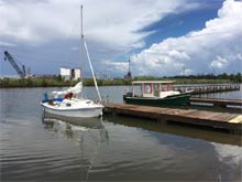 |
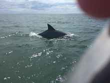
The forecast called for more than 50% rain and heat indexes over 100 degrees all week. It looked like the forecast was starting out just like the forecast said it would and I was prepared for a wet few days. I launched right beside Robert and we left the dock about the same time around noon. On the way out of the Pascagoula Shipping channel, I did a quick recon of the Round Island anchorage because there had been some talk about the recent dredging and artificial island building going on nearby. The anchorage was unchanged although the sand spoil island north of Round Island had more doubled in length on the northern end. Its shallow between Round and the Spoil islands, but deep between the Spoil island and the mainland a mile or two away, you can cut off about 5 miles when traveling east to west by sailing north of the spoil island and south of the mainland but I was on a recon mission. After a quick recon, and determining the anchorage was unchanged from the previous year, I continued westward towards Biloxi. It was, in Murray White's words, "lumpy" with regard to the sea conditions. We all saw dolphins periodically as we sailed the area.
 |
The wind was east southeast at about 10-15 but the wave frequency was 2-3 seconds causing a steep and choppy 1-foot sea and keeping my 1/2 Fast Cruiser at 10-15 mph or so. I entered the Biloxi shipping channel east of Deer Island and then turned in between the mainland and the island's eastern tip. As I traveled along the 5 mile length of Deer Island, between it and the mainland, I saw Duff Basset sailing his Hobie Tandem Island around the anchorage area. I slipped on by him to anchor on the western end of the island near the single tree where we anchored the year before. That area has a little cove in it offering great protection from the east & south and limiting the exposure from the west and north to a couple hundred yards. The water is several feet deep right off the shore allowing us to anchor stern to shore and step off the boat without wading more than a foot or two.
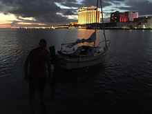 |
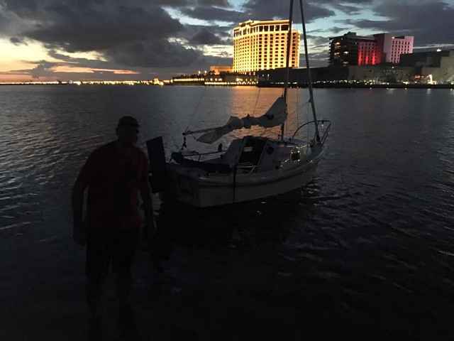
Duff came in right behind me to anchor. Murray White sailed in shortly afterward in his 12ft O'day Widgeon. Robert Harden came in next sailing his Potter 15 from Pascagoula where we had both launched. Travis Votaw & has son John arrived from Oklahoma just before dusk in their 22ft Cat Ketch "Pilgrim" after launching just across from us at the Small Craft Harbor ramp. Travis showed off his offshore sailing skills as he anchored a couple hundred yards offshore from the Hardrock Casino.
Everyone greeted each other and set things up for the night but since most had driven a long way and were sleep deprived everyone tuned in early. We had a great night's sleep with no rain and no mosquitoes. Other than the trains and noise from the mainland it was a peaceful night.
|