 Custom Search
|
| boat plans |
| canoe/kayak |
| electrical |
| epoxy/supplies |
| fasteners |
| gear |
| gift certificates |
| hardware |
| hatches/deckplates |
| media |
| paint/varnish |
| rope/line |
| rowing/sculling |
| sailmaking |
| sails |
| tools |


| join |
| home |
| indexes |
| classifieds |
| calendar |
| archives |
| about |
| links |
| Join Duckworks Get free newsletter CLICK HERE |
|
|
| Inaugural Mississippi Barrier Island Sail - Part Two |
by Mike Mangus
- Columbus, Mississippi - USA |
Part One - Part TwoSeptember 23 – 27, 2015Day 3, Friday, Sept 25th
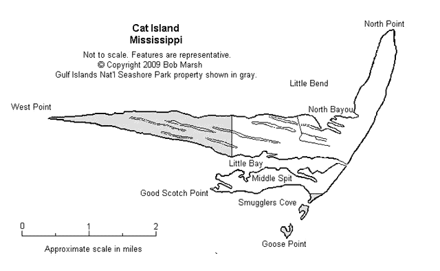
As typical, I do not sleep soundly. Hard surfaces does painful things to my hips and back. At the end of every REM cycle, I wake up and shift trying to find a more comfortable position. Bonus though is watching the nearly full moon track stutter steps across the clear starry sky. Heh. First out is Steven and Dave in the Mariner. They plan on sailing past the proposed Ship Island camp to Cat Island further west. They also plan on camping there before the expected long sail to Round Island tomorrow. A few of us actually doubt they will make Round Island tomorrow with the expected very light winds. Next out is Murray in the Widgeon. He plans on heading back easterly towards Petit Boice Island while hugging Horn Island’s north shore. Knowing Murray, he’ll easily make it and have a good start to Round Island tomorrow. Pilgrim is third out. Travis, Stan, and Pehr plan on sailing to the Ship Islands to possibly roam the fort and camp on East Ship. There is some doubt if they will make Round Island tomorrow also with expected light winds. Pat and I plan on heading to Deer Island straight north near the mainland casinos. After that, we plan on cruising to Ship Islands and try to roam the fort, then back to Deer Island for the night. With tonight’s camp scouted, off we go towards Ship Islands! A smudge on the horizon turns out to be Fort Massachusetts on West Ship Island. Given the prevalent NE wind that makes anchoring off the north shore a pain and a quick decision to explore Cat Island while the seas are relatively smooth compared to the last few days, we forego stopping at the fort and head west-southwest for the south side of Cat. I vow to return someday to spend time visiting and walking the fort. Although not a rabid history buff, I love reading and walking history. Some of my most enjoyable times were spent roaming castles in Europe, temples in South Korea, forts in South Carolina, and WW2 ships across the USA. Pearl Harbor was a treat too. There is something real about treading the same places where history was made. I really want to add Fort Massachusetts to that list! Of all of the Barrier Islands, Cat Island offers the best protection for camping. From here sailors can jump off towards the Mississippi River Delta islands or head back east to the Mississippi Islands. Lots of potentials! After anchoring and setting up tents, we chat with the others while sitting comfortable in the shade of the big tree with a nice mild breeze keeping everyone cool. We are treated to the best sunset of the entire trip. Stan and I swap sleeping places tonight, with him taking the tent and myself in the Pilgrim’s cockpit. Day 3 Video Recap: Day 4, Saturday, Sept 26th Travis and the Pilgrim’s crew decide to head south to see the Ship Islands and the fort, then sailing back to Deer to spend the night with plans to pull out there in the morning. As they get ready to sail, Pat and I load up and get under weigh. In a fit of mischievousness, Pat first heads west for a half mile then comes about on full plane to buzz the Pilgrim as a goodbye gesture. Heh. Pehr messages to say the Pilgrim is turning back and heading to Round Island. They are only making 3 – 4 knots in the light wind and decide they will not have enough time to make the round trip to Ship Islands and back. Heading north cruising the east shore, we spy a tent that looks suspiciously like Murry’s. Wait a moment! Wasn’t he supposed to be spending the night at Sand Island? His boat is nowhere to be seen, so we assume coincidence that someone else has a tent like Murry’s. Point Park Approach Video: Docking amongst a number of power boats using the ramp and nearly shore fishermen, we unload my stuff. Pat decides to refresh in the air conditioned restrooms while I start breaking down the Little Tri for transport. The boat is about half done when Pat wanders over to bid goodby. It is with heartfelt appreciation that I thank him for letting me cruise on his boat for the trip and the times he went out of his way to help me out. I see him off and on the way before returning to the Little Tri take down. Less than an hour later with a drive-through lunch sitting in the passenger seat, I’m on the way back to Columbus, Mississippi. The ride is uneventful (unlike the return drive from this year’s FL120 trip!). Four hours later I’m home and ready for sleep in a comfortable bed.
As the inaugural Mississippi Barrier Island Sail (and power) adventure, we were cautious and did not try to visit all of the islands the first time out. Other than Pat Johnson, I do not think anyone else had made the trip beforehand. Instead of trying to push for all of the islands, participants wisely decided to feel out the waters of the sound and islands for future trips. Even so we were treated to some good sailing and boating to unique and pretty places. There is so much to see that 4 days really isn’t enough time. That is not a bad thing for it allows Captains flexibility to set a course for places best suited for the wind and waves and vessel capabilities. Who can ask for anything better while sailing the Mississippi Barrier Islands? The Mississippi Barrier Guide can be found at: www.barrierislandsms.com/Guide.htm Pictures by Bob Marsh |
To comment on Duckworks articles, please visit one of the following:
|


 |